活動データ
タイム
08:14
距離
10.5km
のぼり
1215m
くだり
1003m
活動詳細
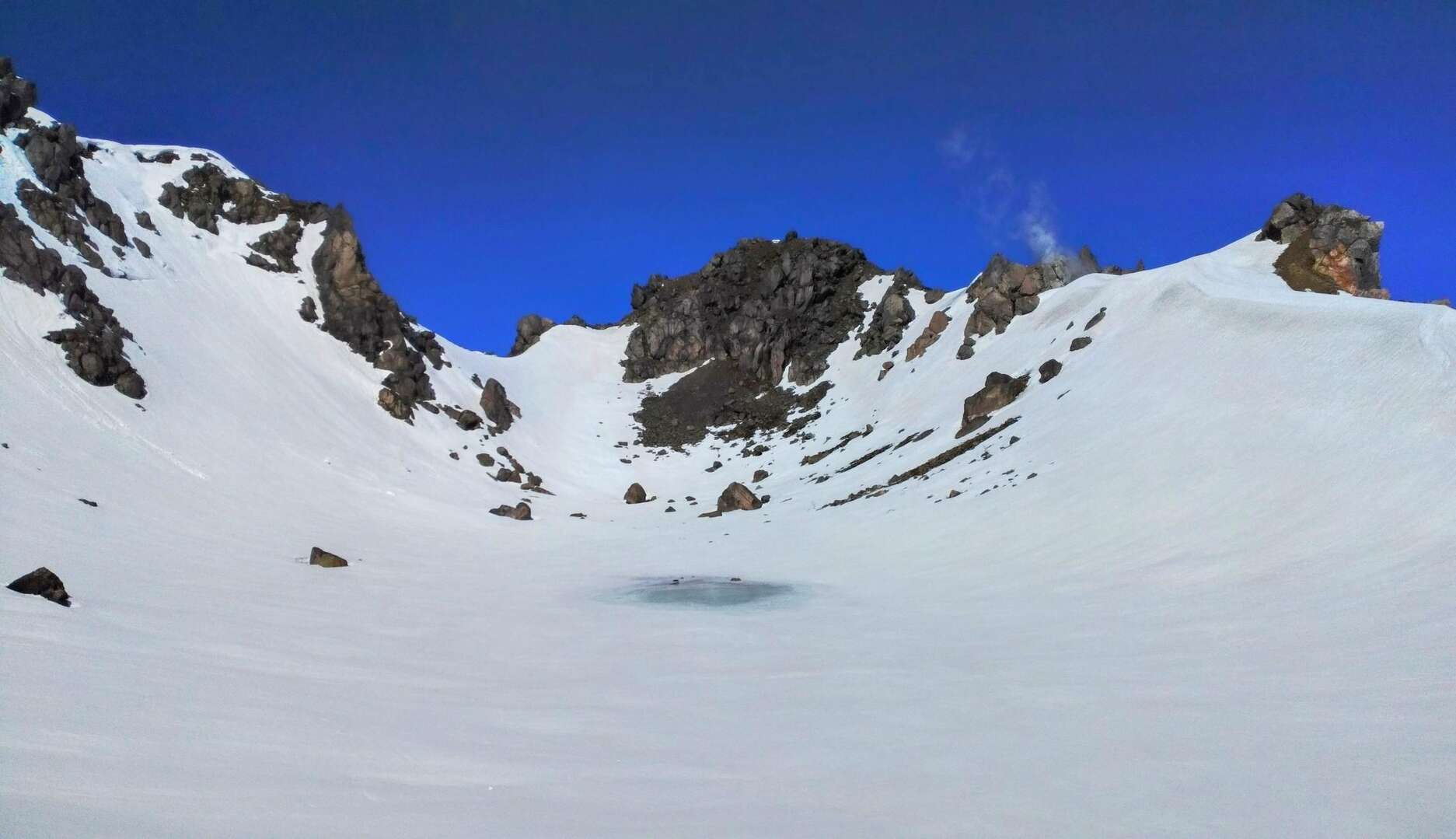
すべて見る(English is below) 三年ぶりの焼岳 今回、南峰も ソロ 南峰~火口湖の正賀池~北峰 頂上:-7℃~3℃ | 登山口:-2℃~10℃ 風速:0〜2m/s 交通 新宿~松本:あずさ特急で2~3時間、片道5950円 松本~沢渡:バスで約1時間、片道1600円 (前夜は沢渡に泊まりました) バス時刻表: https://www.alpico.co.jp/traffic/express/matsumoto_takayama/ 朝5時に、沢渡〜中ノ湯バス停: タクシーで約15分、3200円 中ノ湯バス停~中ノ湯ホテル~登山口: 徒歩約4.3km 何年前友人がここで子熊連れの母熊を目撃、焼岳には熊が多いとも言われている 今回熊よけスプレーを持ってきた 雪は登山道の1/4くらいでほとんど溶けてした 雪は全般的に踏みやすい。まるで歩くアイスクラッシャーのような気分だった 記憶に通り、だんだん、硫黄の匂いがしてきて、北峰付近の噴気口から大きな煙が見える 南峰に向かう道、雪が完全に溶けているところがあり、急で、大きな石や岩が頭上にあるようなところだった。ヘルメットを持ってきてよかったかもしれない。12点アイゼンをつけたまま岩を登るのはぎこちないだった ここはすでに絶景、クマが羨ましくなってきた、生活環境は美しい やがて南峰に着く、3人がいました、食事中 私も何か作ろうと思ったが、9時30分だった、あまり食欲がなく しばらくしてからもう一人の方が到着、ここで写真を撮ってもらいました、ありがとうございます :) 南峰で北峰と噴気口がよく見える 写真を撮った後、北峰へのルートをチェック 北峰に向かって尾根を少し歩いてみて、このままでは北峰に行くのは成算がない、戻りました 火口湖に向かう斜面には足跡があり、斜面の角度はかなり大きい 近づいてみると、人間と野生動物の足跡だった。 動物は北東から、ちょっと乱暴 人間の足跡は北峰の方向に続いているよう 遂に、北峰へは、火口湖まで降り、噴気口の近くへ登っていくことにした 雪崩がおきやすいかも、リスクを取ることにした 火口湖まで、トリッキー、かなり急 実は、前回は火口湖に行きたかった、今日やっと 鞍部に近づく、湖は雪に覆われていた、真ん中だけが見えてきた ここでは、山に煙を出すいくつかの噴気孔が、この湖の背景となり、とてもいい光景だった (南峰から出発した時、ルート記録の再開を失念、地図にルートが表示されていないので、写真で描きました) 噴気口の辺りに到着、雪は完全に消え、こちら側では誰もいなかった 光景と匂いが、3年前の記憶を呼び起こし、灰色の日だった、今は晴れ 硫黄の匂いは3年前より弱くなったような気がする 煙と一緒に、北峰へ ここから先は、雪が残っているが、表面下ですべて溶け始めていた 私は一回沈んでしまった この辺りが好き、巨大な岩、石の温度は手で感じることができる、暖かい 噴気口に囲まれて、焼けるような山 山頂直上の岩場、雪がなかった 北峰に到着、3人がいました 彼らは南峰に行くつもりはないらしく、これから下山するところだった この後、頂上貸切 3年ぶり、焼岳を書いた木の板が真っ二つに割れ、柱もなくなり、どうしたんだろう 天気に恵まれ、絶景 (前回は真っ白だった)南峰は反対側で、人も見えました 誰もいなかったので、頂上で思想が浮遊 南峰へ戻って下山しようかと思ったが、トレースがあったので北峰から下山することにした ミニ雪崩痕跡があった 今回ワカンを持っていったが、雪がかなり固められていたので使う機会がなかった 日差しが強く、暑い、顔全体を布で覆いたい 遠いところ、3人はBC、楽しそう その後、カラスの鳴き声以外、人にも動物にも出会わなかった 締めは中の湯温泉 今日の温泉は熱い、まるでエビのようでした 温泉の後、気分が良く、空の光も良く、音楽をかけながらバス停へ向かった しばらくすると、一台の車が停まり、中に二人がいて、どこへ行くのと聞かれました そして、バス停まで連れて行ってくれました。ありがとうございました :) 焼岳で楽しかった EN 2023.4.2 Solo・ Day-hiking Southern peak ~ Crater lake ~ Northern peak Route: Nakanoyu Weather: Sunny → cloudy Summit: -7℃~3℃ Trailhead: -2℃~10℃ Wind: 0~2 m/s Transportation: Shinjuku ~ Matsumoto by limited express, reservation is required Matsumoto ~ Sawanto by bus, it takes around 1 hour, 1600 JPY (I stayed at Sawanto the night before) Timetable from office website: https://www.alpico.co.jp/traffic/express/matsumoto_takayama/ Book the taxi to Nakanoyu bus stop Time: 15 min, Cost: 3200 JPY / car Nakanoyu bus stop - Nakanoyu hotel - trailhead: 4.3km walking ( I took the shortcut to the trailhead from Nakanoyu hotel) Usually the south peak is prohibited to climb due to falling rocks, but it's okay during winter time. One of my friends saw a mommy bear with her children here many years ago, it’s also said that there are lots of bears on Mt.Yake. I brought bear spray with me this time. Most of the snow melted at probably around 1/ 4 of the trail. Perhaps I should've bought a helmet. I arrived at the southern peak at 9:30, there were 3 people who were taking lunch. The northern peak can be seen from here along with the symbolic fumarole, after some pictures I started to check the route to the southern peak. I walked along the ridge towards the northern peak for a little bit, as I was thinking, at this moment it doesn’t seem realistic to get to the northern peak from here. There were footprints on the slope down to the crater lake, the angle is probably more than 45°. As I got closer, I found that the footprints are from both humans and wild animals, traces intersected. Animals seemed to come from the northeast, footprints of humans seemed to lead to the other side of the ridge. I decided to get to the northern peak from here, down to the crater lake and then up to the ridge that locates the fumarole near the northern peak. This terrain is prone to avalanches in this season. The way to the lake was tricky, quite steep, it wouldn’t be fun if I slip. I took my time. The size of the footprints from wild animals varied, some were big, I wondered if they were from bears. Arrived at the bottom, the lake was covered with snow, really nice. (I forgot to resume the route record when I departed from southern peak, the route didn’t show on the map, I draw it on pictures here) Safely arrived at the fumarole, didn’t see anyone on this side. From here, even if there was still some snow, most of it melts underneath, I miss my foot at one place lol Giant rocks and stones were warm. Surrounded by several fumaroles, it literally indicates that Mt.yake is a burning mountain just like its name. Later, I saw 3 pairs of trekking poles left on the ground, right next to the rocket area leading to the peak. Arrived at the northern peak, 3 people were here. They didn't plan to go to the southern peak and were about to descend. Then it's just me alone. Not much snow left here, the wooden board that got Mt.Yake written was split in half, the column was gone too, I wonder what happened lol I was thinking of getting back to the southern peak then descend, but I saw traces and also I can't be bothered to go back and get up that steep slope, so I descended from the northern peak. I saw traces of mini avalanches. I brought ワカン, but no need to use it since the snow was quite bonded. The sun was strong. Far away, 3 people were skiing down, looks fun. After, I didn’t encounter anyone else or any animals besides the sound of the crow. Ended this trip at Nakanoyu Onsen. For some reason today’s onsen was really hot. I felt like a shrimp lol. Felt good after the onsen, the light from the sky was nice, I played some music and walked to the bus stop. Gonna take some time, but it was peaceful. After a while, a car stopped by, there were two people, and they asked where I was going. Then they took me to the bus stop. Thank you :)
もしも不適切なコンテンツをお見かけした場合はお知らせください。